Sunday 21 January 2018

Track my climb

Team Kilimanjaro have a great website where you can track each of their climbers as they climb Mt. Kilimanjaro.  You can log on at any time to see where we are on the climb.  As it uses google earth you can also use the map to see what terrain we are on and how steep we are climbing at any time.  Just keep zooming in!

We won't appear on there until we start the climb though - so please be patient.  You will know we have set off when you can see us on the list!

Team Kilimanjaro will also share photos on this page as and when they get them.  BUT please be aware that there is no guarantee of a phone signal on the mountain so updates may be short, or a few days apart, depending on the state of the phone signal.

So here is all you need to know:

1) Click here to track my climb.

To access the site from anywhere else simply use the following web address and click on "track a climb" on the top menu bar.

www.teamkilimanjaro.com

2) Once on the Track a climber page, please scroll right to the bottom of the page and open up the instructions...and read them. 😉 You will need to click the cross in the top right hand corner of the box to open it. (See below)


3)  Once you understand what it is you can see on the map, you can open the map by clicking on the relevant link (see below)


4) I am the main party so we will appear on the list of climbers as:

LIPH x 2, 26 Jan - 1 Feb

Don't forget that you can check for photos by heading back to the main track a climber page and clicking on the word 'photos' (see below).

If you wanted more information on the route we are taking remember to check back at my previous blog post that detailed each day.  I have also highlighted the route in the photos below to give you an idea from the map.  The main point is shown in the white circle on each photo below.

Day One - Trek to forest Camp


Day Two - Trek to Shira Camp 1


Day Three - Trek to Moir Hut


Day Four - Trek clockwise around northern slopes to 3rd Caves Camp


Day Five - Trek to School Huts


Day Six - Trek to Crater Camp and get up at midnight to SUMMIT!


Day Six cont. - After summit we descend to Mweka Camp.


Day Seven - Trek to Mweka Gate....and we're done.


As you an see, we chose the long route - not just because more time gives us more chance of acclimatising to the altitude and minimise any risk of altitude sickness - but this route also gives us the opportunity to walk right around the mountain giving us views from every angle.  Most other routes just go up and down the same way, this is a once in a lifetime trip so we wanted to get the best we could out of it.

Saturday 20 January 2018

Altitude

This week I did something I have never done before, and probably will never do again - altitude training.

We have arranged to have five sessions in an altitude chamber to get used to walking at altitude and preparing our bodies as much as we can for what is just ahead of us.  The five days run back to back (apart from the weekend) so we started on Wednesday and will have our last one one Tuesday, the day before we fly.

We are doing the training at St Mary's University in Twickenham.  St Mary's has some of the best fitness training facilities in the country and has been used by many sporting greats including Sir Mo Farrah and David Weir CBE.  The altitude chamber is also used by some F1 drivers as part of their training, unfortunately confidentiality means they can't tell me who - but its great to know I'm standing in the footsteps of some of the greats.  If altitude training is good enough for them, its good enough for me!


We are in the chamber on a treadmill each for an hour at a time.  Just walking, but adjusting our speed and incline every 15 minutes.  One of the treadmills is very high and very wide - its in there for David Weir so we really do feel athletic using his equipment.

Each day in the altitude chamber the altitude is increased and oxygen levels decreased so our bodies can get to used to functioning at altitude.  Day one we started low, reaching 2000m above sea level.  Day two we increased it to 3000m.  At 3000m the oxygen level in the room was 14.5% (normal level is 20.9%).  Day three we upped it again to 3530m and the oxygen again reduced to 13.5%.

The plan is to reach 4000m on day four and 4750m on day five.  It takes the body at least 24 hours to get back to normal oxygen levels - the reason we have left this so late in the day is that when we fly and arrive to start the climb our bodies still will not have reacclimatised to normal oxygen levels and therefore the altitude should not be too much of a shock for us.


This week has also seen the shipment of all the school goodies to Tanzania.  Eighteen boxes in total including books, toys, games and laptops as well as bags for each child at the school.  Thank goodness I don't need to unpack them all again at the other end!!  We are visiting the school at the end of our trip so I will no doubt share some photos of the day.


Liwonde National Park - Malawi

An African Parks project since 2015, totals 548 KM2.  Situated in southern Malawi, ancient baobabs and lofty borassus palms preside over Liwonde's small yet vibrant landscape of dense woodlands, lagoons and fertile floodplains.  While having sustained high levels of poaching over the past few decades, this still productive ecosystems, sustaining over 400 species of birds, the largest elephant population in the country and a flourishing population of plains game mammals, is poised for the reintroduction of large predators.  The restoration of key species and historical levels of biodiversity is re-establishing Liwonde as one of the country's iconic wilderness areas.


The stats....
  • 261 elephants were moved to Nkhotakota in 2016, 550 elephants remain in the park;
  • 78 permanet and 100 temporary jobs created for the local community through fencing and construction projects;
  • 85 rangers trained.
The Highlights
  • Essential infrastructure is being installed and upgraded, including the new 140 km perimeter fence.  Fencing and construction projects have provided permanent and temporary employment for 178 people;
  • Since 2015, 16,000 snares and 40 gin traps have been removed, 43 kg of ivory have been seized and 85 rangers have been trained;
  • The nearby Nanthomba School has been upgraded, and park visits have been provided to local schools;
  • 261 elephants were translocated from Liwonde to help restock Nkhotakota in 2016.
What next for Liwonde?
  • Reintroduction of predators, beginning with cheetah, following completion of the fence;
  • Continue management and monitoring of existing populations of elephant and black rhino;
  • Continue translocation of elephants to Nkhotakota in 2017, with an additional 50 coming from Liwonde  and 200 from Majete;
  • Construct new staff accommodation and roads, and improve access to water and electricity.
All of this information has been taken from the African Parks website.  If you want to find out even more about Liwonde National Park then why not grab a cuppa and click on the link below - happy browsing!

Liwonde National Park 

PS - here is a link to my just giving page - click here to sponsor me ðŸ˜˜

Tuesday 9 January 2018

The climb in numbers - what, when and how

A lot of people have been asking me about the route we are taking, how long it will take and how far we will walk.  I thought I'd do a post all about the climb itself, giving you the climb in numbers, a few stats about each day to give you a flavour of what's in store.

We will be climbing the Lemosho Route - a seven day 'walk' in total.  We chose this route for a number of reasons.  It is not the most popular route with tourists, therefore it will be quieter - and that mean less people to hide from when 'using the facilities' 😉.  Also, most routes are five days in total, that means you get to the top a lot quicker - and that means you are more likely to suffer from altitude sickness.  The key to success is speed, or rather the lack of it.  The slower you go the more likely you are to acclimatise to the altitude, and therefore you are more likely to reach the summit.  Seven days is the perfect length to give us maximum chance of success.

Here is a breakdown of the trek, day by day:

Day One
7.30 am - pick up from hotel for transfer to Longdorissi Gate for registration.  This transfer will take approx. 2 hours (111km).  Following registration we are back in the bus for a further transfer to the starting point.  This can take anywhere between 45 mins and 1 hour 30 mins, depending on the road conditions.  Please pray for good weather as otherwise the bus won't make it through and we will need to walk a 180 meters vertical ascent and a 1.9k trek just to get to the starting point!!

From the Lemosho starting point (2424m) we walk 5.4 km, over 400m of elevation gain to Forest Camp (2821m).  If we are lucky enough we may see some wildlife on this part of the trek.

Day Two
Trek from Forrest Camp to Shira 1 Camp (3508m) on the western edge of Shira Plateau.  The distance is 7.7km.

There is then an optional acclimatisation ascent to Shire Ridge (395km) - Kilimanjaros third volcanic summit) for some great views of Kibo (thats the summit!!).  We then descend to sleep lower at Shira 1 Camp.  This excursion is an additional distance of 7.6km

Day Three
Trek from Shira Camp to Moir Hut (4166m) across Shira Plateau before rising along the flank of a re-entrant.  Height gain 658m.  Distance of this bit is 9.4km.

We then have a sunset acclimatisation before dinner to 4505m of ridge.  A total of 1.9km.

Day Four
Trek clockwise along the northern slopes from Miur Hurt (4166m) via Pofu (4040m) to 3rd Caves Camp (3971m).  This is the longest days walk at 17km.

Day Five
This is a harder day as we trek upwards from 3rd Caves Camp (3971m) to School Hut (4722m).  Although a shorter distance than the last two days at just 4.9km, there will be a height gain of 751m.

On day five we get an early night, in fact so early we go to bed in the middle of the afternoon to get as much sleep as we can - as day six is approaching and thats summit day!!

Day Six
We ascend from School Hut (4722m) via Hans Meyer Cave (5243m) and Gilmans Point (5708m), to Uhuru Peak (5895m).  WE ARE THERE!!  Then we descend to Crater Camp for the night (5729m).

We start the climb to the summit some time around midnight in order to reach the summit between 4am and 5am.  This is to get the best chance of clear views from the top as the sun rises (weather permitting).

It is then usual to descend to Mweka Camp (3090m) for the night for sleep, relief, giggles, stories from the top etc.

Distances on this summit day are:

School Hut to summit - 5.4km
Summit to Barafu - 4.5km
Barafu to Mweka Camp - 6.3km
Total - 16.2km

Day Seven
Descend from Mweka Camp to Mweka Gate (1641m) where we sign the summit register (all being well!).  Thens its just a short 15min walk to our driver....a seat, the hotel, the bath, a toilet, running water, a bar, soap, toilet roll, electricity, phone signal, civilisation....heaven!  Todays walking distance is 8.5km.

And thats it....just a short 78.6km walk up a small hill.

School Visit

Just a quick update while I have your attention on the school visit.  This week we have taken delivery of some re-conditioned laptops from Ashik and Dips in our IT department.  They spent their time over the Christmas break getting the laptops set up for the school and have kindly donated them to our collection.  I'm sure the laptops will be grateful received by the staff at Ikirwa School and will be put to good use.


We have also received 125 Commvault branded school bags, which are brightening up the HR department at the moment.  They are lovely, the only issue is that they all now need to be packed with all the goodies we are filling them with for the children at the school before we can ship them off to Tanzania.

The bags are being packed with notebooks, pens, pencil cases, colouring pencils, t-shirts, water bottles and sweets.  Oh, and lets not forget the 30 footballs and massive pile of books and games that have also been donated.  Commvault employees are great!!


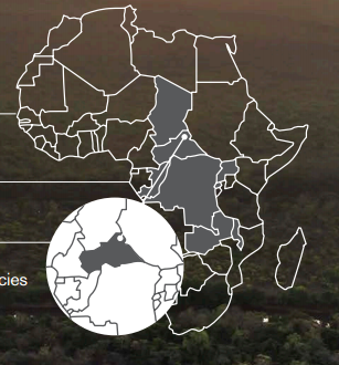
Chinko - Central African Republic

Chinko's mixed landscape of tropical forest and Congolese savannah is one of the only areas in the world where savannah and rainforest animals share the same landscape.  The park is home to as many as ten primate species, five field species, both forest and savannah elephants, and the highly threatened Lord Derby eland.  Despite being located in one of the most conflict-ridden and volatile parts of Africa, Chinko is one of the largest and most critical conservation projects on the African continent.

Providing a wildlife sanctuary for the region, Chinko, which was brought under the management of African Parks in 2014 and for which a 50-year mandate was given, holds the potential of offering a secure and sustainable future for both people and wildlife.


The stats....
  • Over 280 bird species and 80 key mammal species;
  • 60 rangers in first ever law enforcement unit;
  • 400 people employed making African Parks one of the largest employers in the region;
  • The ivory and bushmeat markets have resulted in a 95% depletion of wildlife in CAR.
The Highlights
  • African Parks is one of the largest regional employers with over 440 people;
  • The first ranger unit of 60 rangers was formed from 200 applicants;
  • Anti-Poaching patrols and law enforcement work have doubled the Ngoy Protection Zone to 2,000 KM2, providing security for wildlife;
  • Seven highly threatened Lord Derby eland have been collared for the first ever monitoring programme;
  • 29 'parent teachers' have been employed for 11 surrounding villages.
What next for Chinko?
  • Reduce the presence of Sudanese herdsmen by introducing designated livestock corridors and educating them on reducing conflict with predators;
  • Build permanent staff accommodation and install needed VHF systems;
  • Better equip the law enforcement team to effectively protect the park.
All of this information has been taken from the African Parks website.  If you want to find out even more about Chinko then why not grab a cuppa and click on the link below - happy browsing!

Chinko

PS - here is a link to my just giving page - click here to sponsor me ðŸ˜˜